Image may be NSFW.
Clik here to view. The Dingle Way (Slí Chorca Dhuibhne) is a 153km circular walking trail. The walk begins in Tralee, overlooking Tralee Bay, and then swings southwest across the peninsula from Camp to look down on Dingle Bay while you ramble inland to Annascaul, and then on to Dingle Town. From Dingle the route continues west around Slea Head to Dunquin, with magnificent views of the Blasket Islands to the west and beautiful coastal cliffs to the north. Then the trail turns back along the north coast of the peninsula, past Smerwick Harbour, and continues on below the massive Brandon Mountain, Ireland's second highest peak and named for St. Brendan the Voyager. A high pass will bring you to the village of Cloghane, east of Brandon, and then the route continues along coastal beaches to Castlegregory and the Maharees, ultimately ending back in Tralee.
Image may be NSFW.
Clik here to view.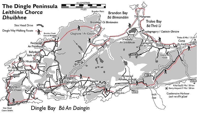
The Irish Trails website details the route. For convenience they have divided the Way into 13 sections, each representing a half days walking. Detailed maps (in PDF format) can be downloaded:
Dingle Way - Overview Map
Map 1 Tralee to Derrymore
Map 2 Derrymore to Knockbrack
Map 3 Knockbrack to Inch and Annascaul
Map 4 Annascaul to Lispole/Lios Póil
Map 5 Lispole to An Daingean/Dingle
Map 6 An Daingean/Dingle to Cill Mhic an Domhnaigh
Map 7 Cill Mhic an Domhnaigh to Dún Chaoin and Baile an Fheirtéaraigh
Map 8 Baile an Fheirtéaraigh to Feohanagh
Map 9 Feohanagh to Más an Tiompáin
Map 10 Más an Tiompáin to Cé Bréanainn
Map 11 Cé Bréanainn to Stradbally
Map 12 Stradbally to Castlegregory
Map 13 Castlegregory to Camp
