Dingle Peninsula Tourism has compiled a collection of looped and linear walking routes. |
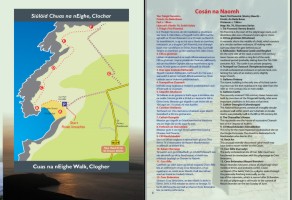
Siúlóid Chuas na nEighe
Clochar, Baile an Fheirtéaraigh.

This is a cliff top walk of under two miles which begins and finishes at the car park above Clochar Beach about eight miles west of Dingle. It takes in spectacular sea views and the surrounding countryside and headlands. The walk is flat and has three or four stiles.
DESCRIPTION (EveryTrail.com)
MAP (PDF format)
Lúb na Cille
Start: Blasket Centre car park

Spectacular way-marked coastal 5 kilometre walk in Dún Chaoin.
This is one of Ireland's National Looped Walks.
DESCRIPTION (DiscoverIreland.ie)
MAP (PDF format) (Fáilte Ireland)
Slí na Sláinte
Location: Dingle Town
 Slí na Sláinte means 'path to health'. Developed by the Irish Heart Foundation - the national heart and stroke charity - it's the outgoing way to make walking far more enjoyable. You'll find Slí na Sláinte walking routes all over Ireland.
Dingle's Slí na Sláinte is 3.3 kilometres long, starting at the roundabout on entering the town from Tralee.
DESCRIPTION AND MAP (Irish Heart Foundation)
Siúlóid Cholmáin
Location: Ventry

Looped walk on bothareens and beach.
Historical sites include Colman’s Oratory and Rathinane Castle.
DESCRIPTION (PDF Format)
MAP (PDF format)
Glanteenasig Wood - River Trail
Location: Glanteenasig Wood, between Camp and Castlegregory

Glanteenasig is a 450 hectare state owned woodland abounding with streams, lakes, waterfalls and dramatic cliffs.
DESCRIPTION AND MAP (CoillteOutdoors.ie)
Siúlóid a' tSáis - Sauce Creek Walking Trail
Start and Finish: Cé Bhréainainn/Brandon Village

A four to five hour walk in bogland and hills in the vicinity of Sauce Creek/An Sás.
DESCRIPTION (PDF format: copyright Comharchumann Forbartha an Leith Triúigh)
MAP (PDF format)
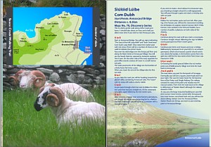
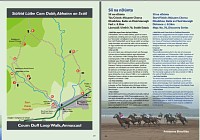
Coumduff Loop Walk, Annascaul
Start and Finish: The Old Bridge, Annascaul Village

A one and a half hour gentle stroll around the lanes of Annascaul visiting the birthplace of sculptor Jerome O'Connor and burial place of polar explorer, Tom Crean. The walk can be extended to visit Annacaul Lake.
DESCRIPTION (PDF format)
MAP (PDF format)
Slí na Dúnta, Baile an Fheirtéaraigh
Start and Finish: Músaem Chorca Dhuibhne, Baile an Fheirtéaraigh

An 8.5 kilometre heritage walk around the lanes and beaches near Ballyferriter.
DESCRIPTION (PDF format) (westkerrymuseum.com)
MAP (PDF format) (westkerrymuseum.com)
Slí an Mháimín, Baile an Fheirtéaraigh
Start and Finish: Músaem Chorca Dhuibhne, Baile an Fheirtéaraigh

An 8.5 kilometre heritage walk on minor roads circling the hills near Ballyferriter. A number of archaeolgical sites, including early Christian sites and a medieval tower house lie on the route.
DESCRIPTION (PDF format) (westkerrymuseum.com)
MAP (PDF format) (westkerrymuseum.com)